|
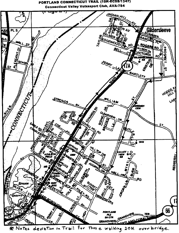
PORTLAND TRAIL (10K-EC98/1347) Connecticut Valley Volkssport Club, AVA-784 Welcome to Portland Connecticut! 1998 NOTE: START WITH THESE DIRECTIONS IF: 1. You do not wish to cross the bridge, and want to walk 10K 2. You wish to walk 20K AND cross the bridge. Although Portland was established as a town in 1841, the areas' modern history began in 1672, when the Wangunk Indian tribe deeded a tract of land along the Connecticut River to the fledgling city of Middletown, which had established itself nineteen years earlier. As you walk our streets you will learn of the towns assorted and unique history from the Indian residents of the meadows, the colonial shipbuilding industry which thrived here, and the brownstone quarry industry of the late 17th through the early 20th century to our present residential community. |
|
|
DIRECTIONS |
COMMENTARY |
|
1. Start: DUNKIN' DONUTS, 152 Main Street. (Rest Rooms available at start/finish) |
The first half mile of this walk travels the nineteenth-century business district. Small gable-to-street stores and many old houses in this area have held numerous thriving businesses over the past 150 years. Before |
|
2. Left on Main Street to Freestone Avenue (first cross walk) |
that time, the center of town was two miles north, in the Gildersleeve area. As brownstone became popular and profitable the town's center |
|
3. Cross Main Street, |
shifted to this area near the brownstone quarries. |
|
4. Left on Main Street to Fairview Street (second right, across from Portland Middle School) |
East Main Street is an 1890's version of the suburban development we saw back on Edgewood Road and Taylor Drive from the 1960's--a sudden burst of houses, removed from the owners' place of work. This was a new |
|
5. Right on Fairview Street to East Main Street (first left) |
idea when it first came about in the later 1800's. Freestone Avenue is a similar phenomenon, dating from a bit earlier. |
|
6. Left on East Main Street to Church Street (second left) |
Notice the 1889 Central School building at this intersection, it is being repaired for use as our town office building and is featured on the |
|
7. Left on Church Street to Main Street. (first right) |
"A" Award for this years event. The next half mile, beginning approximately at the 1940 post office, |
|
8. Right on Main Street to Edgewood Road. (left after fire house about 1.2 miles) |
shows the kind of residential charm which could have characterized Portland in the 1800's. Many of these houses were built by men who drew their wealth from the quarries. |
|
Check point # 1: What is the Name of the school on your right after passing Brownstone Monument on Bartlett Street? Record your answer on line 1 of your Walk Card. |
After Coe Avenue, named for Captain Wellington Coe whose house stands on the northwest corner, the old houses are spread out. The land here was farmed, unlike the previous smaller house lots of quarrymen and merchants near the town's center. Of course twentieth century houses have filled in the streetscape. You will notice from the signs that |
|
9. Left on Edgewood Road to Hale Road (first right) |
settlement along this stretch goes back to the 1700's. Land along Main Street was originally dealt out to settlers in long strips, running east from |
|
10. Right on Hale Road to Palmer Road (first left) |
the Connecticut River towards High Street, which will be on our return route |
|
11. Left on Palmer Road to Ann Street (first right) |
This comfortable suburban area which includes Edge-wood Road and Taylor Drive was created around 1960. |
|
12. Right on Ann Street to Olson Avenue (first left) |
As you near the north end of Taylor Drive, you will be walking into the area which was one of the earliest Indian reservations in |
|
13. Left on Olson to Taylor Drive (firt right) |
the country, reserved to the Wangunks in 1673, then sold to the English in 1765. |
|
14. Right on Taylor Drive to Indian Hill Avenue (first right) |
Indian Hill Avenue bisects the smaller part of the reservation. Most of its houses were built for and by shipyard workers. The square brick store on |
|
15. Right on Indian Hill Avenue to Main Street (first right) |
the corner of Indian Hill and Main was Gildersleeve Store, incorporating its own post office. |
|
16. Right on Main Street to Summer Street (first left across form Gildersleeve Spirit Shop) . |
Summer Street heads us into the larger portions of the Wangunk reservation, which extended to the Congregational cemetery, a half mile east. The tiny brook that passes under the road once marked the dividing line: English to the west, Wangunk to the east. |
|
17. Left on Summer Street to Prospect Street (first right) |
In the vicinity of Bartlett Street, named for Portland's beloved Rev. Moses Bartlett (1708-1766), begins the section known as Gildersleeve. Once |
|
17, Right on Prospect Street to Bartlett Street (last right) |
again, old houses are closer together, indicating thicker early settlement, and people who made their living in the shipyards rather than from |
|
18. Right on Bartlett Street to High Street (first left) |
extensive farming. Ship building began in this area around 1740, but it took an entrepreneur named Sylvester Gildersleeve (1795-1886) to make the area famous for its shipbuilding. Among other things, Sylvester Gildersleeve contracted to build the ships to send brownstone building blocks to places as far away as New York and San Francisco. |
|
19. left on High Street to Spring Street (third right, about one mile) |
High Street also marked a similar boundary between Wangunk and English land. One of the Wangunks, Moses Cuschoy, served on the three-man surveying team that laid out the road in the 1750's. The first church in Portland, built in 1721, stood at the intersection of High and William streets, probably in the road, traffic being what it was in those days. Spring Street is so named because of a spring, shared by several Main Street homeowners of the 1800's, that ran in this vicinity. |
|
20. Right on Spring Street to Main Street (last left) |
In some respects, you have walked backwards through time in Portland. You saw the business and residential development of the 1800's in the current ``center,'' the farming and shipbuilding of the 1700's further north in Gildersleeve, and at the top of the area, the Native American presence, |
|
10K: 21. Cross Main Street and turn left to DUNKIN' DONUTS, Start/Finish.20K: 21. Left on Main Street to bridge. Be very careful crossing Marlborough Street. |
now virtually obliterated, but stretching back thousands of years. All the features of the landscape you traverse have a story to tell, so keep walking and looking! We hope you enjoyed your visit to Portland! If you have any comments, please pass them on to us c/o Bob McDougall, P. O. Box 251, Glastonbury, CT 06033-0251 (860) 342-3062 |
Specific Sites to note as you walk
|
188 Main Street: |
Portland Restaurant. Built in 1884 as Laverty's Saloon, after a raging fire destroyed the earlier building. |
|
231 Main Street: |
Portland Funeral Home. Frederic Hall house, built 1845. |
|
245 Main Street: |
Liberty Bank. Alfred Hall house, built 1839. The architect was the famed A.J. Davis. |
|
246 Main Street: |
Chubbie’s Restaurant,. House built by Joel Hall Jr. in 1805. |
|
265 Main Street: |
Town Hall, built as a private home in 1852 by quarry owner Jonathan Fuller. |
|
269 Main Street: |
Fleet Bank. This building was built in 1925, but a bank has occupied this site since 1865. |
|
314 Main Street: |
Portland Middle School, built in 1932 on the ``cattle lot.'' The stone sling on the lawn is depicted on the town seal which appears on the event award. |
|
325 Main Street: |
The Brainerd Sisters house, built in 1889 by their brothers' and fathers' quarry profit. The name ``Stonehaven'' was given to the building in 1942. |
|
336 Main Street: |
The Haynes Ransom house, a perfect example of the Carpenter Gothic style, built between 1872 and 1874. |
|
345 Main Street: |
Trinity Episcopal Church, built between 1872 and 1874. |
|
381 Main Street: |
Methodist Church built in 1853. |
|
405 Main Street: |
Elisha Covell house, built around 1855. |
|
478 Main Street: |
Deacon Samuel Hall house, built 1708 on a unique room plan, with the stairwell running from front to back. (See also 119 High Street.) |
|
487 Main Street: |
(Corner of William and Main) Note ``reindeer'' in porch trim. |
|
492 Main Street: |
Ruth Callander house. Built in 1711 by Nathaniel White. |
|
533 Main Street: |
Capt. John Worthington house, built 1841, added onto in 1911. |
|
554 Main Street: |
Congregational Church, built 1850. This was the third building. |
|
601 Main Street: |
Gildersleeve Firehouse built 1889. |
|
604 Main Street: |
John Ilsley house, built 1869 on a partial foundation of John Savage house, built in 1735. |
|
Indian Hill Ave: |
is on the National Register of Historic Places due in part to its 18th and 19th century architecture, and in part to its early use as a Wangunk Indian burial ground. |
|
31 Indian Hill Ave: |
Petzold's shipyard, site of shipbuilding since the mid 1700's. |
|
5 Indian Hill Ave: |
The David Bates house, built 1779. Bates was a privateer during the Revolution. In the 1850's the house was lifted so that a tavern, called the Union Hotel, could be put in the basement. It survived until Prohibition. |
|
3 Indian Hill Ave: |
The Job Bates house; Job, David's father, built this house illicitly on Wangunk land in the 1740's, before it had been legally purchased from the tribe. |
|
643 Main Street: |
the Captain Giles Hall house, built 1714. Hall properly applied to the General Assembly to buy his 6 acres from the Wangunk. |
|
646 Main Street: |
Portland Floor and Wall, built in 1855 as Gildersleeve Store. |
|
644 Main Street: |
Gildersleeve Spirit Shop built in 1855 by Samuel Buckingham. |
|
Corner of Prospect&Bartlett: |
The second Congregational Church building occupied the northeast corner of this intersection from 1748 till 1850. |
|
145 High Street |
look back over your right shoulder for a view of Hartford. |
|
Corner of High & William: |
Note the brownstone marker for the first Congregational Church building, on the southeast corner. |
|
119 High Street: |
the Ebenezer Smith house, built 1708. This house has the same unique floor plan as the Deacon Samuel Hall house on Main Street. |
|
49 Spring Street: |
look slightly to your left for a magnificent view of the Arrigoni Bridge, built in 1936. |
|
East Main Street: |
the Episcopal Church cemetery. The graves in the north end were moved from the earliest graveyard near the Connecticut River so that the land could be quarried for brownstone. |
|
33 East Main: |
Central School, built in 1889. |
|
Traffic Warnings: * State law requires that pedestrians walk on the left shoulder of the road (facing traffic) when there is no sidewalk. * Use caution when crossing Main Street to Rogers Road as there is no crosswalk. * Remember to cross Main Street at the end of Freestone Avenue, as you finish the walk, this is the last crosswalk before the bridge. Places for refreshment along the trail: |
|
|
DUNKIN' DONUTS |
156 Main Street. |
Brooks Pharmacy |
Main Street. |
|
Portland Restaurant |
188 Main Street. |
Portland Country Market |
272 Main Street. |
|
Kimberly’s Restaurant |
246 Main Street. |
Gildersleeve Spirit Shop |
644 Main Street. |
|
Credits: The Connecticut Valley Volkssport Club and the Portland Historical Society wishes to express their appreciation to Doris Sherrow for her contribution of the historical descriptions noted on this trail map. Questions: Call Bob McDougall 342-3062 Please leave comments in our Guest Book. |
|||